A couple of years ago I decided to take running a bit more seriously and to try to keep track of when, how much, and how fast I run. As a dedicated Apple-afficionado and beginner runner, the obvious choice was the Nike+ sensor (which you place in the sole of your shoe), coupled with an iPod Nano. I have been using this setup for about two years now, and I was fairly happy with it. It was easy to start using it, it definitely helped me run more and faster than before, and GPS units were just too big or too nerdy (even for me) to carry around on a Saturday morning run in the park.
However, it has always bugged me that the precision and accuracy of the Nike+ system was far from perfect, and I knew that GPS watches could do much better, not to mention that you can also put your run on a map. I caved in to the temptation a few days ago and ordered a Garmin Forerunner 110 GPS watch; here are some initial observations.
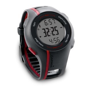
The Forerunner 110 is designed to be relatively small and simple, with limited functionality. In other words, it is targeting people like me: mostly outdoor runners (it is not very good for biking and useless for indoor running) who don’t need all kinds of functionalities that most other Garmin GPS watches have. It gives you basic information like pace, time, distance, and heart rate (if you are using it with a heart rate monitor), and that’s about it. The relatively small size and reasonably good (=minimalistic) look means that you can wear this gadget on your wrist pretty much every day, without looking like a total nerd.
In terms of usability, the Forerunner 110 does pretty well. It doesn’t rely on the touch interface that is built into the latest and greatest Garmin sports watches; instead, it has four large buttons that are easy to push when you want to — or not to push inadvertently when you don’t want to. This can be important in the middle of a sweaty run when you are not really in the mood for the subtleties of dealing with a sensitive touch interface. For example, I often have problems with the touch-wheel of the iPod nano. Recording a run basically comes down to (1) waiting until the watch gets a GPS fix; and (2) pushing the ‘start/stop’ button. In my limited experience, getting a GPS fix works pretty well and relatively fast, although it did take about 5 minutes the first couple of times. That is too much for a runner. Yesterday and today however it was much better, it locked on to the satellites in less than a minute.
So far so good. The one major issue I ran into was that, after a first recorded run, when I wanted to upload the data to the Garmin Connect website, I couldn’t get the watch to talk to my MacBook. It took lots of trial-and-error and one-and-a-half hours on the phone with the Garmin help desk to figure out that the charging clip that’s supposed to attach to the four exposed contacts on the back of the watch was not exactly where it should have been, despite the fact that the watch was charging (or it looked like it was charging anyway). This might be just a reflection of my limited intellectual capabilities, but I doubt that I am the only one who will run into this problem.
When it comes to uploading your workout data to a website for visualization and analysis, the Garmin ecosystem definitely leaves the Nike+ setup in the dust. The obvious advantage is the visualization of your runs in Google Maps. This is a major plus for a map-lover; but in addition to that, the Garmin Connect website makes it very easy to export the data and visualize it with Google Earth or any other software that can handle geospatial data. No export options exist for the runs you have recorded with the Nike+ sensor. In addition, the quality and usability of the Garmin graphs showing pace/speed through time is way better than the flashy but largely useless attempt that Nike has put together. Compare these two graphs (representing the same run):

Nike+ website

Garmin Connect
The Nike+ graph is pretty close to useless, whereas the one from Garmin Connect looks like a plot based on real data and it shows real trends (e.g., that I was running significantly slower during the last half of the run). And this is not a reflection of poor data quality coming from the iPod software; it turns out that the resolution of that data is much better than what Nike shows you. In general, Garmin treats the workout data in a much more scientific yet simple manner, also giving you the options of taking the data elsewhere, whereas the Nike website is colorful and animated, but has limited and closed information that has been dumbed down too much for my taste.
To wrap it up, despite a few – hopefully short-lived – annoyances, I am fairly happy with this new gadget. I will try to find out later how well it can be used for geotagging photographs while hiking or doing field work, something I still don’t have a simple solution for.
Update (6/20/2010): I have been using this watch for more than a month now. It works pretty well for running, although I did have a problem today: it froze at one point, and I couldn’t record any new data. It was very hot and humid, and I guess the contacts on the back side of the watch couldn’t handle the amount of salty sweat I was producing. Now it works again. Also, it is a good idea to turn on the GPS reception a few minutes before you start the run because sometimes it still takes 2-3 minutes to get the coordinates.
In terms of using it for hiking and geotagging photographs: I did a hike using both this watch and an older Garmin unit, and noticed that the accuracy of theForerunner 110 is better than that of the Garmin eTrex Vista Cx. The watch worked much better in the forest and in a deep, narrow valley, where the GPS signal must have been weak. The problem is that the battery of the Forerunner 110 doesn’t last long enough for a full-day hike; after about 5 hours of constant GPS recording, I couldn’t use it any more.
Update (2/4/2011): It looks like this watch (certainly the one that I am using) has a major flaw: when connected to a computer, the USB connection is easily broken because of the questionable design of the contacts on the back of the watch and the clip. The watch freezes and the only way I could get it back to life was to do a hard reset. This means that any data you have on the watch is lost. I have lost running data due to this issue several times; the last time it was especially annoying since it successfully got rid of the GPS record of my first marathon. Thanks, Garmin!
Update (3/30/2012): The problem I mentioned in the update above hasn’t occurred since I did a software update. However, a few months ago (about one and a half years after I bought the watch) the strap broke and I don’t think there is an easy way to replace it. Also, often (but not always) it takes 20-30 minutes to get a GPS lock. It is time to get a new watch, and I think I will stay away from Garmin for now.