Memorable moments and photos from 2013

We are well into 2014 now, but it is not too late to look back at 2013 and pick some of the best moments (which means photos in my case) of the year that just passed.

We started out the year with a trip to Zion and Bryce Canyon National Parks. Although it was fairly cold (especially at Bryce Canyon NP — this park has a much higher elevation overall than Zion NP), we had lots of sunshine and did several day hikes. Visiting these parks in the winter is a great idea — they are a lot less crowded than in the summer, and obviously the landscapes and sights are quite different when they are covered with snow.

Zion National Park is paradise for a sedimentologist: there are endless, top-quality exposures of the Navajo Sandstone, showing all kinds of sedimentary structures characteristic of deposits of wind-blown sand. I have included two examples here; you can find more on my Smugmug site.

Sedimentologically, Bryce Canyon National Park is a bit less exciting than Zion, but this is counterbalanced by the fantastic geomorphology of this place. I haven’t seen Bryce Canyon in the summer, but I wouldn’t be surprised if it was more beautiful when it’s covered with snow.

In February, I went on a ‘business’ trip to Torres del Paine National Park in Southern Chile: I attended a field consortium meeting organized by Steve Hubbard’s group at the University of Calgary. I have been to this area several times before, as it has some of the best outcrops of turbidites (= deep-water sediments) in the world, but I was once again shocked how uniquely beautiful Chilean Patagonia can be.

At the end of the official trip, Zane Jobe (who is blogging at Off the Shelf Edge) and I did a bit of geo-turism: we went to see Glacier Grey and Lago Grey, and then did a day hike in the park to check out the actual Torres del Paine. The rest of the photos are here.

In July, my wife and I took a few days to do some hiking and running in Rocky Mountain National Park. I was struggling with a running injury at that time, but the mountains and the trails acted as efficient tranquilizers. More photos at Smugmug.

In September I attended a research conference on turbidity currents in Italy and Peter Talling showed us some of the classic outcrops of the Marnoso-Arenacea Formation. These rocks are very unique because they were deposited by huge submarine flows that covered the entire basin floor. Always wanted to see them and it was enlightening to get up close to them.

DSC_6304

Turbidites of the Marnoso-Arenacea Formation, Italian Apennines. David Piper and Bill Arnott for scale

In October we spent a long weekend in Moab, Utah, to participate in our first trail races, but we also did some hiking. Running the Moab Trail Marathon was an amazing experience (I think I will have to do it again this year); unfortunately I didn’t take a camera with me, as I was trying to focus on running (and surviving the race).

DSC_6470

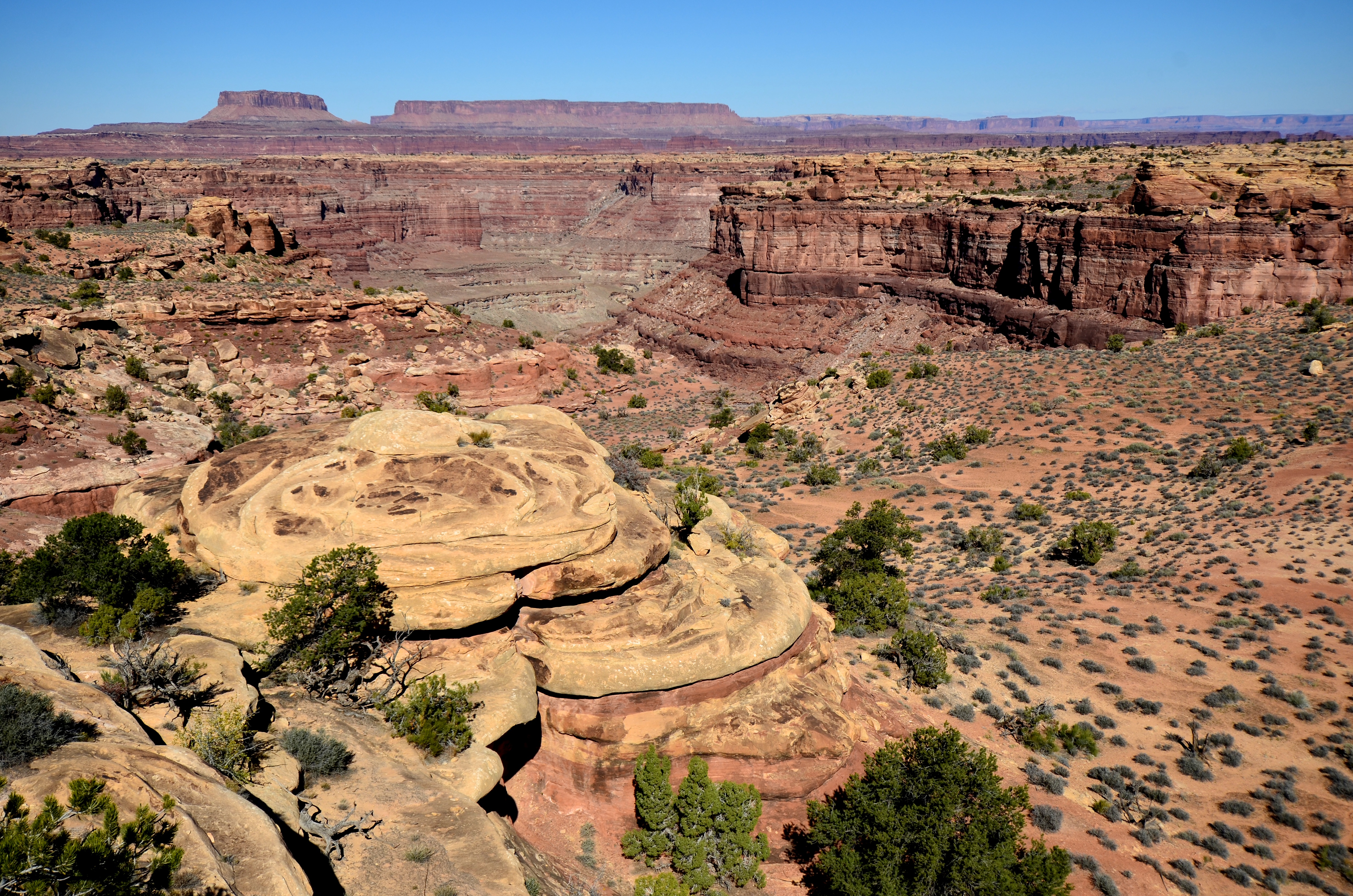
Typical view in Canyonlands National Park

To continue with the theme of ‘national parks in winter’, some friends from California and the two of us wrapped up the year with a Christmas trip to Yellowstone and Grand Teton National Parks. More photos, of course, at Smugmug.

Wave ripples on an eroding beach

I shot these photos in 2003, at Sea Rim State Parkin east Texas, close to the border with Louisiana, a relatively remote and beautiful state park along the Gulf coast that suffered a lot of damage during both Hurricane Rita in 2005 and Hurricane Ike in 2008. On that chilly November day the light was great and the variety of shapes and patterns created by wave ripples and exposed during low tide was amazing.

Wave ripples are more symmetric than current ripples. Needless to say, wave ripples originate thanks to the back-and-forth movement of sand by waves, whereas current ripples form under unidirectional flows (like rivers and turbidity currents). Wave ripples are also more regular than current ripples, extend for much longer distances laterally, and often terminate – or continue – in ‘Y’-shaped junctions. For the same wavelength, they are also taller; the L/H ratio of most wave ripples is between 4 and 10, in contrast with current ripples that have an L/H value of ~20.
Perfectly symmetrical ripples form under bidirectional currents that are perfectly symmetrical themselves; but this tends to be the exception rather than the rule, as shoaling waves create a net shore-directed movement of the water. The resulting ripples are asymmetric, with the steeper side facing the coast, but still more symmetric and more regular than pure unidirectional ripples. Weak tidal currents can cause the asymmetry as well. The photo below shows wave ripples with a significant asymmetry that makes them difficult (if not impossible) to distinguish from current ripples.
This set is also asymmetric, but to a lesser degree:
Sea Rim State Park is at a location along the Gulf coast where the beach is eroding and the coastline is retreating; it is a typical example of a transgressive coast. The erosion is the results from both sea-level rise and from lack of longshore sediment transport strong enough to nourish the beach with sand. The evidence for the transgression is quite obvious: banks of well-consolidated muds that were originally deposited in the lagoon behind the coastal barrier are being eroded by the advancing waves:

More on wave ripples at Olelog.

A hike in the Bucegi Mountains, Romania

Recently I had a chance to revisit a fantastic hiking trail in the Bucegi Mountains, located in the Romanian Carpathians (or Transylvanian Alps, for those who prefer a more exotic name). The Bucegi are among the most spectacular hiking and climbing places in Eastern Europe, with some of the tallest cliffs in the region. Back in the good old days when I used to live closer to some significant topographic relief (as opposed to a living on a %^$#@ flat passive margin), this hike was one of our favorites. The main attraction is a steep climb along a valley floor that usually has some snow even during the summer months. In the steepest sections there is no proper trail and usually there is nobody else around; this is the perfect place if you want some outstanding scenery without the crowds.

The predominant rock type in these mountains is the Bucegi Conglomerate, a Cretaceous formation with lots of limestone clasts. The limestone pebbles, cobbles and boulders were eroded from Jurassic carbonates that outcrop in the western parts of the Bucegi. This is one of the thickest conglomerate accumulations I have seen and I know of; its thickness reaches 2000 meters in places. It was probably deposited as fan deltas along a rocky coast, with rivers that were directly depositing coarse-grained sediment onto a submarine slope. There is evidence for deposition by sediment gravity flows: many conglomerate layers show no obvious stratification (which one would expect in a river deposit) and normal  grading is common. Toward the top, there is one spectacular layer, likely deposited by a single flow, with limestone blocks tens of meters across. [These blocks are often called olistoliths.]

Typical Bucegi Conglomerate (photo taken in 1995)

Originally these rocks were described as ‘molasse’ (one of those terms that probably were invented only to hide our ignorance about the relationships between mountain building and sedimentation), likely reflecting deposition in shallow marine environments. In the late seventies, when the idea that thick piles of coarse sediment could be of deep-marine origin was still big news in geology, the Bucegi Conglomerate actually made it onto the pages of Nature.

http://maps.google.com/maps/ms?ie=UTF8&hl=en&msa=0&msid=105339637352396792358.0004897bc14eab05b635f&ll=45.431265,25.49273&spn=0.029012,0.080263&t=h&output=embed
View Bucegi Hike in a larger map

In any case, our hike in June was long and strenuous (see the map above), but the weather was outstanding and we had the whole mountain to ourselves: apart from the meteorologists at the Omu Peak, we haven’t seen a human being while hiking.

Here are a few more photographs (see the rest at Smugmug):

There is still plenty of snow in the ‘Valea Alba’ (‘white valley’) in June
The artist previously known as erosion
That’s all conglomerate
When you clearly need a log-scale for grain size (note the two limestone ‘grains’ and the normal grading above the lower one)

This picture gives an idea how big the limestone blocks in the previous photo are: note the two guys in the front for scale

Texas wildflowers

The weather has been awesome around here lately (yes, in Houston!, the weather!, awesome!), and otherwise uninteresting roadside places are starting to be flooded with colors. Here are a few shots; more over at Smugmug.

This one is actually from 2008:

One of the issues with photographing flowers is that parts of the pictures are often out of focus, as it is obvious in this shot:


And a way to deal with that is to take a number of pictures that are focused at different distances and then merge them in Photoshop (as described in this video). This image was put together from four different photographs, and is a somewhat better version of the previous scene (the fact that the wind was pretty strong didn’t help):


Lunar Crater volcanic field, Nevada


I was on my way to San Francisco / AGU last week when I saw these volcanoes and shot these pictures through the airplane window. It turns out that this is the Lunar Crater volcanic field in Nevada, named after the largest crater that is more than 1000 meters across and about 130 m deep. There are 95 vents that are 4.2 million to 15,000 years old. Lunar Crater is the largest feature in the image below; it is a maar; most of the other vents formed cinder cones.


Here is a map showing the Houston – San Francisco flight track and the location of the volcanic field:

Two gigapans from Cliffs of Moher, Ireland

I shot these gigapans recently, while we were visiting some deep-water rocks in County Clare, Ireland (see more detail on these rocks and a few photos from the trip). One afternoon we took some time off from the turbidites to do a bit of geo-tourism at the Cliffs of Moher, a series of spectacular escarpments along an 8 km long stretch of the western coast of Ireland. They are 702 feet (214 meters) high at the highest point and expose Late Carboniferous (Namurian) sandstones and shales that were mostly deposited as deltaic and fluvial sediments of the Tullig and Kilkee cyclothems.

This place is one of the most visited tourist attractions in Ireland, and for a good reason: the combination of the cliffs, the landscape, and abundant wildlife is, indeed, spectacular.

This is a view to the south (launch full screen viewer):
http://api.gigapan.org/beta/gigapans/27345/snapshots/87490,83479,83403,83402/iframe/flash.html

And this is a view to the north (from O’Brian’s Tower; launch full-screen viewer):
http://api.gigapan.org/beta/gigapans/27340/snapshots/83397,83395,83394,83392,83391/iframe/flash.html

Unfortunately, these stamp-sized windows do not do justice to the panoramas; it is a good idea to click on the “Launch full-screen viewer” links.

Three photos from Chilean Patagonia

I was lucky to attend a few days ago a field conference in southern Chile, looking at deep-water rocks in an area that includes Torres del Paine National Park. It was good to be back in this place of unbloggable beauty. The conference was well organized (of course! – Brian was one of the conveners) and we were extremely lucky with the weather: no rain at all on the outcrops, beautiful sunshine most of the time. Although I have been to Chilean Patagonia three times before on various geological field trips and even did some field work there, I realized during this conference that it doesn’t matter how many times you have seen some rocks, there is always a chance to rethink what you thought you have already settled in your mind (see blog title). It was also good to see that these field conferences are increasingly not just about the local geology: many if not most presentations and spontaneous discussions compare the local outcrop data with sedimentary systems from other basins, and try to think about how the always-too-small outcrops would look like in seismic sections and volumes.

Brian did not have time to take a lot of photos, so here are three shots (more here). As if anybody needed more shots of the Paine Grande and the Cuernos.

Conference participants examine the turbidites of the Punta Barrosa Formation

The Paine massif (Paine Grande and Cuernos), with Rio Serrano in the foreground

Strong winds on Paine Grande

Update – here is a Gigapan:

function FlashProxy() {}
FlashProxy.callJS = function() {}

http://gigapan.org/viewer/PanoramaViewer.swf?url=http://share.gigapan.org/gigapans0/18452/tiles/&suffix=.jpg&startHideControls=0&width=42349&height=11090&nlevels=9&cleft=0&ctop=0&cright=42349.0&cbottom=11090.0Launch full screen viewer

[it is strongly recommended that you do launch the full screen viewer if you want to do justice to the Gigapan]

Earth, water, wind, and fire: ‘Lava viewing’ in Hawaii

Our Christmas gift to ourselves was a little trip to the Big Island of Hawaii, something we were thinking (dreaming) about for a long time. There are many great posts about the Hawaiian volcanoes on the geoblogosphere (see for example the ones here and here); I will try to add a few notes and pictures without being too repetitive (and will try to seem less ignorant in volcanic and hard-rock matters than I actually am).

Probably the most memorable experience we had was the lava viewing at Kalapana. This is where ‘officially’ you can get relatively close to the place where the lava from Pu`u `Ō`ō enters the ocean. The USGS has a nice website with updates on what’s going on. I was so anxious to see this place that we had to go there on our first day in Hawaii, that is, on December 22. You have to drive all the way to the end of road 130; there are some big ‘No trespassing’ signs at one point, but everybody seems to ignore them, and there is an official parking lot at the end of the road, way beyond the ‘no trespassing’ signs. It is best to get there 30-60 minutes before sunset, and to stay until it’s completely dark, to see the potential show both in daylight and in nighttime darkness. Unfortunately, on December 22 we didn’t see much, apart from a beautiful sunset and a few small puffs of steam:

Sunset at the Kalapana viewing site on December 22, 2008

That was a bit of a disappointment, but I knew I had to give it another try. After talking to a ranger from Volcanoes National Park, we drove back to Kalapana five days later. This time, the show was definitely on. More than that, it was spectacular. A huge column of steam formed where the active lava tube spills the lava into the sea, and repeated explosions painted red the lower part of the column. From time to time, several tornado-like funnels formed and connected the steam cloud to the ocean.

Steam cloud with mini-tornadoes on December 27, 2008; lava-viewing boat on the left for scale

As the sun goes down, the explosions become more colorful and more obvious

S-shaped funnel between the steamy sky and cool hot ocean

This was such a uniquely beautiful scene. I wish we went there more than two times, because the whole spectacle changes as a function of the activity of lava flow, weather conditions, the direction and nature of lighting.

I have also learned that it is not easy to take good photographs of fast-moving and rapidly changing distant things in the dark. Here is the proof: