With some help from Wikipedia, I found that the image posted by Joe was from a volcanic field in western Sudan. So here comes WoGE #62.

Compared to the Peruvian meanders, this should be easy. Extra points for knowing the story that this place is a good example of — there is a specific journal article I am thinking about.
Schott rule in effect (post time 8:22 pm CST, 10-17-07).
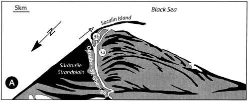
Update: Brian has the answer; here is a bit more detail about this image. It’s the southernmost distributary of the Danube Delta in Romania, called the Sfantu Gheorghe channel. The geometry of the deposits is determined by (1) the river discharge, (2) the wave energy of the Black Sea, and (3) the southward oriented longshore transport. The asymmetry of the lobe is a function of the ratio between the net longshore transport rate at the mouth and river discharge. The longshore currents erode the beach/barrier bars on the northern side of the channel mouth. More details in this paper. This image also comes from Bhattacharya and Giosan (2003):

Black represents sand, gray is predominantly muddy deposits, and the white arrow at the river mouth shows the direction of longshore drift.