
Thanks to the Landsat program and Google Earth Engine, it is possible now to explore how the surface of the Earth has been changing through the last thirty years or so. Besides the obvious issues of interest, like changes in vegetation, the spread of cities, and the melting of glaciers, it is also possible to look at how rivers change their courses through time. You have probably already seen the images of the migrating Ucayali River in Peru, for example here. This river is changing its course with an impressive speed; many – probably most – other rivers don’t show much obvious change during the same 30-year period. What determines the meander migration rate of rivers is an interesting question in fluvial geomorphology.
The data that underlies Google Earth Engine is not accessible to everybody, but the Landsat data is available to anyone who creates a free account with Earth Explorer. It is not that difficult (but fairly time consuming) to download a set of images and create animations like this (click for higher resolution):

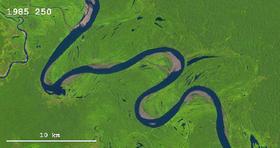
This scene also comes from the Ucayali River (you can view it in Google Earth Engine over here) and it is a nice example of how both neck cutoffs and chute cutoffs form. First a neck cutoff takes place that affects the tight bend in the right side of the image; this is followed by a chute cutoff immediately downstream of the neck cutoff location, as the new course of the river happens to align well with a pre-existing chute channel. The third bend in the upper left corner shows some well-developed counter-point-bar deposits. There is one frame in the movie for each year from 1985 to 2013, with a few years missing (due to low quality of the data).
Update (04/14/2016): If you want to use the animation, feel free to do so, as long as you (1) give credit to NASA/USGS Landsat, (2) give credit to me (= Zoltan Sylvester, geologist), and (3) link to this page. Note that you can see/download the high-resolution version if you click on the image.
Update (04/15/2016): Matteo Niccoli (who has a great blog called MyCarta) has created a slower version of the animation:

Psst. Can I use your image with a linkback to you for a Space io9 post?
Yes, of course.
Very illustratuve animation! Can i use it for an article about flood damage in a local newspaper? please contact me by email if you have any questions.
Best regards
Christian Eide
Christian – yes, feel free to use it.
Hi Z,
I’d like to use your riverschangingthroughtime illustration and would like to appropriately credit you. How do you wish to be credited? I’d like to include your name, position and school or other?
Thanks for this wonderful visual. I have never seen anything as good. I appreciate all the time that it must have taken. Your dedication is most appreciated.
Jim
Jim, thanks for the comment. Feel free to use the image. If you want to put my affiliation, I work for Chevron.
Pingback: Watch a river change its path over the years | Tech +
Pingback: Watch A River Change Its Path Over The Years | LandSurvival.com
I actually did some research on quantifying the change on this section of river about 10 years ago using Landsat….back when it cost $10,000 to buy the imagery from USGS. Very cool to see this data become publicly available and accessible.
Pingback: Witness Peru's rapidly changing river metamorphosize over 30 years - Holy Kaw!
Pingback: See How a River Totally Changes Over Time in This GIF - The Deadline
Pingback: See How a River Totally Changes Over Time in This GIF « Fribliss
Pingback: Witness Peru’s rapidly changing river metamorphosize over 30 years | EzNews
Pingback: See How a River Completely Modifications Over Time in This GIF
Pingback: Witness Peru’s rapidly changing river metamorphosize over 30 years - Motorcycle Classifieds
breathtaking…
Pingback: See How a River Totally Changes Over Time in This GIF – Gizmodo
Pingback: Rivers through time | Buren B. DeFee II, Ph.D., GISP
This is a great example of using satellite data over time. I was wondered if we would be allowed to use the animated gif in our training course material as an example of mapping change over time? I’m thinking nothing more of embedding it in a power point slide to show course delegates this is the sort of thing you can do. These are courses that people pay to be on and of course you would be credited.
Pingback: See How A River Totally Changes Over Time In This GIF | Gizmodo Australia
Pingback: See How A River Totally Changes Over Time In This GIF – DailyITfix.com- Get Your Geek Fix
Seeing this on Nathan Yau’s enewsletter gave me quite a start. I thought for a minute that I had a bird’s eye view of the past. Then I realized it was far too green! In 1977 I was part of a mapping project on the Senegal River in west Africa. The first 200 km had been mapped by some other group, and we used their 2-year-old map to boat upriver to our own starting point. Ran aground numerous times, because of course, the shifting sands of the river bottom did not keep themselves in their mapped locations.
Seeing this LandSat time-lapse has been a trigger for great memories and, I hope encouragement that this kind of evidence will help prevent the waste involved in so many first-world-funded third-world projects. I witnessed the current state of several other prior amelioration projects as I visited the markets in various towns along the river to purchase food. Silted up irrigation projects. Electrical projects that ran on gasoline generators when gasoline was impossibly expensive and hard to get. Pumps that could not be repaired simply or locally.
Of course we completed our amazing (for the time) real-time plotting of the river as far as Mali, where things dry up outside of the wet season. A lot of work, months of employment for our Senegalese workers and for many engineers and programmers and hangers-on. A ‘heart of darkness’ journey for me as the contentious issue of having a female onboard a working boat ebbed and flowed, resulting in me being alternatively sent off to stay in St. Louis at our base in the home of a German reforestation specialist, and welcomed back onboard with the team.
I guess that experience has influenced my subsequent ‘career’ in more ways than I thought. I realize that my current work developing a certificate program in GIS and data mapping using open source (QGIS) software at the local community college is directly related to that long-ago experience with transponders and depth sounders and my relationship with a technologist in marine geophysics. A relationship that barely outlived the lifetime of the project itself.
Anyway, thanks for the nostalgic moment.
Pingback: Changing river path seen through satellite images | Illustrated Monthly Blog
Pingback: جردن نیوز » تماشا کنید: تغییر مسیر شگفت انگیز یک رودخانه طی ۲۸ سال
Pingback: Los curiosos cambios del Rio Ucayali a lo largo de 30 añosa | NCD Agencia
Pingback: Bag of Randomness for Tuesday, April 5, 2016 |
Great gif — lots of interest from others to share and use it! I’d like to do the same with your permission and credit to you — I’d like to post it on my school website for Geography students to see. OK with you?
Sure, feel free to use it!
Man this is a great use of landsat imagery! It seems you share your work freely, I was wondering if you’d also be willing to share the source images that was used to make the gif? Regardless of the answer, well done on the work. I will be sure to pass this on to many of my fellow Remote Sensing peers.
Pingback: Rivers through time, as seen in Landsat images | Gold Ridge Resource Conservation District
Just came across your awesome GIF on reddit.com/r/interestingasfuck. I’d love to put a little text on the GIF explaining what’s going on and then promote the video on Business Insider’s Facebook page. Could you give me permission to make your GIF into a quick video?
Sure, feel free to use it.
I’d like to use your riverschangingthroughtime illustration and would like to appropriately credit you.
I have never seen anything as good.
Hi, this is amazing. May I use the image for my blog? Thanks in advance.
This is such a quick learning experience. I have been in the rafting business for 35 years and I’d like to use this to show changes in rivers. I’d like to link to this for my websites blog for comparisons purposes to what is happening to our local river. Thank you for doing this work.
Nelida, Firman, David: feel free to use the animation.
Fantastic animation Sylvester! Would you post a slower version as well? I’ve taken the liberty of playing with the gif file. As an example, here’s a link to a version I slowed to 1/6th of the origina speedl: https://mycarta.files.wordpress.com/2016/04/ucayali71_slow.gif
Fascinating to see how quickly — in relative terms — the old riverbed disappears..
Great job, creativity! Just wondering if there is any explaination for the dramatic change in the course of the smaller river (upper left corner of the image) in the 2005-to-2006 period as it shifts directly into the Ucayali River?
Pingback: weekly 298 | weekly – semanario – hebdo – săptămânal – haftalık – 週刊 – týdeník – edisi
Fantastic. They’ve come a long way , especially with sat imagery since the flying spot scanner in the 60’s. Nice work putting this together to show the dynamism of a river over time.
Fascinating images! Would you mind if I used them in an article for a Japanese language social media site I work for? We’d be sure to give credit and link back to you, if you don’t mind.
Feel free to use it — see comment about this in blog post.
Pingback: Same same, but different » Blog Archive » Changing river path seen through satellite images
Can I assume North is towards the top of the images?
And this river is flowing North? Thank you!
Hi, I’m helping compile a textbook page on Libretext for UC Davis about oxbow lakes and floodplains, may I use this .gif and link this page?
Hi LeAnne — yes, feel free to use it.