Zoom, baby, zoom*

For a few months now, I have been spending (wasting?) some time with a gadget called Gigapan, a robot that can take hundreds of shots of the same scene with a simple point-and-shoot camera. The pictures are taken in a well-defined rectangular grid pattern so that there is the right amount of overlap between all neighbors. Later the photos can be stitched into a gigantic photograph on a computer and shared with the world through the Gigapan.org website and, even better, through Google Earth. [If you are a tiny bit familiar with geoblogs, you must have seen some of the gigapans that Ron Schott has put together; he is one of the earliest and most enthusiastic adopters of the technology and has assembled an impressive set of panoramas on the gigapan site.]

I have to confess that I had to actually buy this thing and start playing with it to realize how different gigapixel panoramas are from the usual few-megapixel digital photographs. The idea is simple: a ten megapixel camera takes photos that contain ten million pixels; if you put together a 10×10 grid of such photographs into one image, you end up with a gigapixel panorama. Because some overlap is needed between the photographs, more than 100 pictures are necessary to exceed the gigapixel limit. But the point is that the more pixels there are in a photograph, the more information it contains and the more sense it makes to zoom in and see the details – details that are usually non-existent in a conventional digital picture. The other side of the coin is that it is only worth taking gigapans of scenes with plenty of small-scale and variable detail (although I am getting to the point that I see a potential gigapan everywhere).

I do not think that gigapixel images will replace conventional (that is, megapixel) photography. There is only a limited number of things that the human eye can see at one time; and often the value of a good photograph comes not from the pixels it captures, but from the ones it consciously ignores. Beauty and the message an image can hold are scale-dependent; and zooming in to see the irrelevant detail could be a distraction.

That being said, I am all for taking home as many pixels as possible from outcrops and landscapes in general. The gigapan system is simple and works surprisingly well, and it *is* exciting to explore big outcrop panels from the scale of entire depositional systems to the laminae of single ripples or even grains.

No photos or panoramas posted/embedded this time; but here is a link to my giga-experiments.

* title is courtesy of Kilgore661

Liesegang bands in sandstone

Liesegang bands are poorly understood chemical structures often seen in rocks, especially sandstones. They were discovered more than a hundred years ago by the German chemist Raphael E. Liesegang, when he accidentally dropped a drop of silver nitrate solution on a layer of gel containing potassium dichromate, and concentric rings of silver dichromate started to form.

In sedimentary rocks, Liesegang bands appear well after the sediment has become a rock (that is, it got compacted and cemented). Stratification and lamination within the sansdtone are typically cross-cut by the Liesegang bands; fractures usually have a more obvious effect on the distribution and orientation of these.

The rocks shown here are turbidites of the Permian Skoorstenberg Formation, in the Karoo desert of South Africa. This Liesegang banding developed in the neighborhood of a small thrust and consists of brown bands of iron oxide that entirely ‘ignore’ the original lamination of the sandstone (not visible in the photos), but clearly like to precipitate along some of the fractures in the rock.

Hurricane sedimentology

Hurricane Ike knocked me off the Internets for a while, but things are slowly getting back to normal. I haven’t been so close to – that is, in the middle of – a hurricane before; I have to say it was quite an adrenaline rush to hear and, to a lesser degree, watch the wind going by our windows with gusts of (probably) more than 100 miles per hour. In Houston, the damage was largely restricted to fallen trees and a few broken windows; fortunately not too exciting (see a few post-Ike photos over here). However, things are very different as you get close to the coast. Along the East Texas coast, the storm surge (unusually large for a category 2 hurricane) has shifted the coastline a few tens of meters landward, deposited lots of washover fans toward the lagoonal sides of the barrier beaches, and destroyed a large number of homes in the meantime.

It is worth playing the before-and-after game with the aerial imagery shot by the NOAA’s Remote Sensing Division and made available in Google Earth. Here are a few screenshots from the Bolivar Peninsula.

Before:

After:

The light-colored lobes in the upper part of the ‘after’ image are the washover fans that in places reach the lagoon. Even more interestingly, there are some beautiful little fans built by the water flowing back toward the sea; for each fan, you can see the erosional ‘drainage’ area and little tributary gullies merging into a single large channel seaward, that turns from erosional to depositional as it widens. This is more clear in the zoomed-in pictures below.

Before:

After:

Note how some of the streets and roads that were perpendicular to the coast have become sites of preferential water flow and therefore locations for these channels.

Of course, all this cool sedimentology (I cannot wait to be able to get out there and have a closer look) also means that many-many homes have just become part of the stratigraphic record. These beaches and islands are the product of the interaction between storms like Ike, when large amounts of sand is eroded from the beach and transported offshore, and fairweather conditions, when sand has some chance to be deposited on the beach (if there is a large enough source of sand somewhere – usually not the case along most of the present-day Gulf coast).

The message should be already boring, but apparently it is not: these beaches and the barrier islands they create are geologically extremely active creatures, and in general it is not a good idea to build homes on them, certainly not right next to the beach. Hurricanes will be around for a while (and some experts say they are getting larger and stronger); and they are very good at creating large storm surges that are highly destructive on shallow shelves with low gradients, such as the continental shelf in the northern Gulf of Mexico.

Water escape structures in a Cretaceous delta, Wyoming

I spent a few days in Wyoming, at a conference and field trip focusing on clinoforms, organized by SEPM (Society for Sedimentary Geology). Clinoforms are sedimentary layers with a depositional dip of a few degrees that form packages of relatively large thickness (let’s say more than a few meters; could be hundreds of meters in some cases. The point is that the foresets of ripples, sand dunes and other bedforms could be called clinoforms but they should not be). [Warning! – my definition]. After a couple of days of morning talks (many very good ones) and afternoon posters, we spent two additional days visiting some outcrops in southern Wyoming.

These photos come from exposures of the Maastrichtian Fox Hills Sandstone of the Eastern Washakie Basin, a sandstone of deltaic and fluvial origin that links through shaly clinoforms to turbidite sands and shales of the Lewis Shale, deposited in water depths of more than 400 meters (see reference below).

The photo above shows one set of smaller-scale clinoforms truncated by a cross-bedded sandstone unit above, probably of fluvial origin. This is a prograding shoreline. It was a matter of debate whether the erosional surface at the base the fluvial sands is a sequence boundary or not, and could be a blogworthy subject in itself, but I will refrain from discussing it here and now. What I think – at least visually – are more exciting are the water escape structures in the photograph below.

There are two sandy layers visible in the picture; the lower one is somewhat darker colored and more massive-looking than the upper one, which is more laminated and has an overall lighter color. The height of the rock surface covered in the photo is about 1.5 m.

A likely explanation for the structures is as follows (sorry for the arm-waving — it would be nice to put some numbers here – sedimentation rates etc., but life is too short for that right now). Soon after the first (darker) layer was deposited, another flood of the river brought more sediment to this location, and started depositing sand, mostly along a flat bed that resulted in parallel lamination. The underlying sediment was still very porous and unconsolidated, and some of its pore water was trying to get to the surface as the weight of the overlying deposit increased. Thin layers of finer-grained and therefore less permeable sediment got in the way however; and the escaping pore water had to travel laterally until it found the most vulnerable spots to go again upward. There are two of these vertical water escape conduits in the photo. As all the water coming from the lower layer had to go through a limited number of these spots, the velocity of the pore fluid must have increased significantly, until it actually was able to fully suspend the sand it encountered. In other words, some of the sand along these vertical escape zones got fluidized and carried away. The white structureless patches of sand are sedimentary intrusions. The light color suggest that these sands are much ‘cleaner’ than the rest of the rocks; the finer grains (responsible for the darker color) were washed away.

One interesting detail is that the trough cross-bedded sand between the two intrusions thickens into the depression, suggesting that the water was trying to get out in real time, that is, at the same time as the upper layer was being deposited.

Below I linked in an amateurish-looking gigapan; and here is another post on water-escape structures.

Launch full screen viewer

Reference:
Carvajal, C.R. & Steel, R.J. (2006), Thick turbidite successions from supply-dominated shelves during sea-level highstand. Geology, 34, p. 665-668.

Fossilized snake with exploded head

There is a temporary exhibit called “Geopalooza! A Hard Rock Anthology” at the Houston Museum of Natural Science. If you are in Houston this summer (until August 24), this is something absolutely worth checking out: you can see some outstanding geodes, crystals, meteorites, and fossil specimens. I have been to many natural history museums, but I rarely get as high as I did at the HMNS the other day [‘getting high’ is the right terminology here: you get to (or have to) listen to Led Zeppelin and Bob Dylan while looking at the rocks]. Even if you are not too much into rocks, minerals, fossils, and natural science in general, these pieces are so beautiful that they can simply be viewed as works of art.

Here is for example a fossil snake from the Eocene Green River Formation in Wyoming. This formation has not only one of the most significant fossil sites in the US, but it also contains the largest oil shale deposit in the country: there are 1.5 trillion barrels of shale oil within the former lake sediments. Preservation of both fossils and of organic matter requires special conditions on the lake bottom: a partial or total lack of oxygen not only prevents oxidation of organic material, but also makes life difficult for critters that otherwise would totally churn the sediment and leave no undisturbed animal remains behind.


One of the museum curators was around when I was checking out this snake and she explained that the reason why the head bones are in such a disarray – compared to the beautifully arranged backbone and ribs – is that, as the snake’s body started to decompose, the easiest way out for the accumulating gases was through the head.

I think this snake must belong to the species Boavus idelmani, and is probably one of the best preserved fossil snakes in North America.


The rest of the photos from Geopalooza are here.

Three photos from Vargyas Valley, Transylvania

A few weeks ago I have spent some time back home in Transylvania (it is actually a place previously known as home), and took a day to visit a special place, the ‘canyon’ of the Vargyas River; we used to do a lot of caving and hiking here when I was in high school. A small patch of Mesozoic limestones was somehow forgotten in the middle of a lot of softer pyroclastic deposits, and a nice little canyon developed, with lots of caves and typical karst morphology. Make no mistake, this is not a ‘grand’ canyon, it is not even among the largest canyons in Romania or Transylvania.

But often it is lesser known and more hidden places that have a special atmosphere, a special combination of colors, shapes, shades and minor details that you can never forget.

The Vargyas River

One of the caves

Chlorophyll rules at this time of the year

More pictures here. And here is a map:

The internal structure of the Peyto Lake delta

ResearchBlogging.org I have pledged a while ago not to blog about Peyto Lake anymore, but I have recently discovered some beautiful GPR profiles that I have to share to make the story more complete.

Derald G. Smith of the University of Calgary and Harry M. Jol of the University of Wisconsin – Eau Claire have looked at the internal structure of the Peyto Lake delta using a technology called ground-penetrating radar (GPR). The principles used in GPR data acquisition are similar to those of reflection seismology, but electromagnetic waves are used instead of acoustic energy, and reflections occur at boundaries with different dielectric constants rather than boundaries with different acoustic impedances. Compared to reflection seismic surveying (or digging a deep hole), the nice thing about GPR is that it is non-destructive: it can be used in situations where you want as little disturbance as possible. For example, it would be a bad idea to do seismic surveying of a leaking reservoir, but it is OK to look for the leaks using GPR. GPR is also used by archaeologists.


But let’s return to Peyto Lake. Although it has long been postulated that coarse-grained deltas with steep slopes (called Gilbert deltas, after the American geologist G.K. Gilbert) have a simple internal structure consisting of a topset, foreset, and bottomset, – and there are numerous ouctrop examples that show small coarse-grained deltas with such a structure -, it is not easy to prove that modern-day active deltas behave the same way. You can easily walk around on the top of the Peyto Lake delta and examine the surface morphology and characteristics in as much detail as you want; but without cool technology like GPR you can only wonder what does it look like inside. [Digging a large trench in the middle of one of the most beautiful national parks is not an option.] So Smith and Jol set out to check whether the topset-foreset-bottomset geometry is valid for this delta or it has a more complicated internal structure.

With only one day of data collection in the field (kind of unusual in the earth sciences!), they have clearly shown that the river feeding Peyto Lake is indeed building a textbook example of a simple Gilbert-type delta. The near-horizontal topset layers consist of gravels deposited by the braided river that is active today on the top; the underlying foresets are also likely to be coarse-grained and they dip at about 25 degrees toward the lake. This angle is close to the underwater angle of repose.

It is somewhat puzzling why the authors do not talk at all about the fate of finer-grained sediments (sand, silt, mud) that enter the lake; it is clear that turbidity currents directly originating from the river mouths are important agents of sediment transport in the lake (see more about this here). [They were probably focusing on presenting the results of the GPR survey.] The GPR signal is strongly attenuated in sediment finer than sand, and this might be the reason why reflections get poorly defined in the area where the bottomset is supposed to develop. In fact, I am not convinced I can differentiate the ‘bottomset facies’ the authors talk about.

So here is a representative GPR dip section showing the topset and the foreset:

It is also worthwhile looking at a section perpendicular to this; note how different the topset and foreset look like in this direction. Reflections are much more discontinuous in this image, suggesting that the spatial scale of sediment transport is more limited in a direction perpendicular to the river flow on the top of the delta (this is kind of obvious) and perpendicular to downslope processes within the lake (this is not so obvious).

Reference
SMITH, D., JOL, H. (1997). Radar structure of a Gilbert-type delta, Peyto Lake, Banff National Park, Canada. Sedimentary Geology, 113(3-4), 195-209. DOI: 10.1016/S0037-0738(97)00061-4

Where on (Google) Earth? #138

It must be obvious by now that I am a lazy blogger – it looks like I settled down to a comfortable and boring average of one post per month.

But. I got back my WoGE-mojo yesterday, and bumped into Peter’s WOGE screenshot while gliding over the karstified limestones of the Dinarides in Montenegro.

So here is WoGE number 138. No rules. Have fun.

Crop circles of the deep sea

If ‘cereologists’ (people who seriously think that crop circles are made by aliens) knew about deep-water trace fossils, I am sure at least some of them would argue that these structures must also be the work of extraterrestrial intelligence. Many of the traces are so intricately constructed that they raise the question: how is it possible for a not-too-brainy animal to create such patterns.

This group of trace fossils is called ‘graphoglyptids’ (don’t ask me why) and they are usually found on the soles of turbidite sandstones, layers of sand deposited in the deep sea (that is, in water depths of more or much more than a few hundred meters). Their shapes can be relatively simple meanders, can include multiple levels of meandering, meanders with bifurcations, spirals, radial patterns. The most interesting and most famous member of the group is Paleodictyon, an easy-to-recognize trace fossil with almost perfect honeycomb-like hexagonal patterns.

Many years ago I was lucky to do some work on trace fossils of the Carpathian flysch with two of the best trace fossil experts; since then I haven’t worked with trace fossils but now I wish we did more documentation of the trace-fossil-rich outcrops in the Romanian Carpathians. The Paleodictyon pictures below show turbidite sandstone soles from the Buzău Valley; I haven’t been there for a while but I hear that many of the outcrops are covered now.

The first weird thing about graphoglyptids is that they developed high diversity in an environment with limited amounts of low-quality food (lack of sunlight, hence no primary production; and stuff that sinks down from the photic zone usually has already been food for some other animal). The second weird thing is that they are not simple grazing traces like the tightly meandering patterns of sea urchins; the most widely accepted idea is that they are farming traces. In other words, these guys (whatever they might be, nobody really knows) create well aerated open burrow systems a few millimeters below the sea floor, with multiple openings to the sediment surface, so that chemosynthetic bacteria move in to get the necessary oxygen to oxidize methane and hydrogen sulphide, their favorite food.

Again, despite the abundance of these traces in turbidite successions, it is not clear what is the animal that likes to build delicate hexagonal burrows in the deep sea. It is clear however that the exact same structures have been found near the Mid-Atlantic Ridge. In 1976, Peter Rona of Rutgers University and his colleagues were looking at photos of the Atlantic seafloor and discovered some interesting geometric patterns of black dots. When Adolf Seilacher of the University of Tübingen, probably the most famous trace fossil expert, saw the pictures, he got very excited: he became convinced that it was a modern Paleodictyon. Unfortunately, no other data than the photographs with the black dots was available; no animals recovered from the sediment, and no hexagonal patterns seen below the surface. It took more than 26 years before Rona and Seilacher had the opportunity to do a new dive with the submersible Alvin and to show that the black dots on the seafloor indeed represent small shafts that belong to a hexagonal pattern a few millimeters below, a pattern identical to Paleodictyon (more details in an article by Peter Rona in Natural History Magazine; picture below is from the same article and is © of The Stephen Low Company).


This story is fascinating as it is, but it is best to see it in amazing colors and resolution, in the IMAX movie “Volcanoes of the Deep Sea“, a documentary about the black smokers of the Atlantic and the discovery of modern Paleodictyon.

The mystery of the tracemaker of Paleodictyon – and all other graphoglyptids – remains unsolved: despite the outstanding success of taking IMAX-quality pictures at the bottom and the middle of the Atlantic Ocean, no animal was ever found in the sediment samples, and we know much more about how actual crop circles are generated than we do about the behavior of Paleodictyon.

Further reading

A beautifully illustrated new book by Adolf Seilacher:
Seilacher, A. (2007) Trace Fossil Analysis. Springer, 226 p.

Paper on trace fossils in the Carpathian flysch:
Buatois, L.A., Mangano, M.G. and Sylvester, Z. (2001) A diverse deep-marine ichnofauna from the Eocene Tarcau Sandstone of the Eastern Carpathians, Romania. Ichnos, 8, 23–62.

Links to this post: Book of Barely Imagined Beings

Some questions about the ‘megatsunami chevrons’: addendum

ResearchBlogging.org A couple of months ago I have written about some coastal ‘chevron dunes’ that have been interpreted as the onshore deposits of humongous tsunamis. The subject has been on the tip of my fingers for quite some time and I thought I managed to google up most of the related papers, news articles, and blog posts, but it turns out that I missed one highly relevant discussion: in the January 2008 issue of GSA Today, there is a short paper by Nicholas Pinter and Scott E. Ishman of Southern Illinois University, entitled “Impacts, mega-tsunami, and other extraordinary claims“. [Note to self: looking things up in Google and Google Scholar is not always enough, not even for blogging.]

Pinter and Ishman criticize both the idea that several impact-related megatsunamis occurred during the last 10,000 years and the hypothesis that a 12,900 year old impact caused “Younger Dryas climate event, extinction of Pleistocene mega-fauna, demise of the Clovis culture, the dawn of agriculture, and other events”. The first idea is promoted by Dallas Abbott (at Lamont Doherty Earth Observatory) and her co-workers, but there is no real peer-reviewed publication yet; the second has been put forward by Richard Firestone (of the Lawrence Berkeley National Laboratory) et al. in Proceedings of the National Academy of Sciences and a book. The evidence for the 12.9-ka impact includes magnetic grains, microspherules, iridium, glass-like carbon, carbonaceous deposits draped over mammoth bones, fullerenes enriched in 3He, and micron-scale “nanodiamonds”. Pinter and Ishman suggest that

the data are not consistent with the 4–5-km-diameter impactor that has been proposed, but rather with the constant and certainly noncatastrophic rain of sand-sized micrometeorites into Earth’s atmosphere.

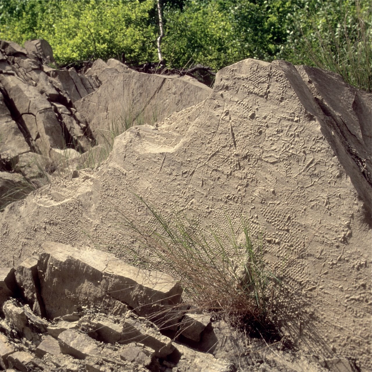
But I am going to focus here on the ‘chevron dune’ part of the story. Pinter and Ishman have essentially the same main issue that I have blogged about: landforms that are morphologically identical to the so-called chevron dunes are well-known in the literature and they are called parabolic dunes. There is no need to introduce a new term:

We suggest that these Holocene features are clearly eolian, and that the term “chevron” should be purged from the impact-related literature.

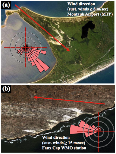
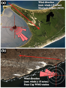
The eolian origin of the alleged megatsunami deposits is difficult to deny taking into account that wind direction measurements at two sites perfectly match the orientation of the sand dunes (figure from Pinter and Ishman):

Dallas Abbott and her co-workers address Pinter and Ishman’s criticisms in a short reply. This is what they have to say about the chevron dunes:

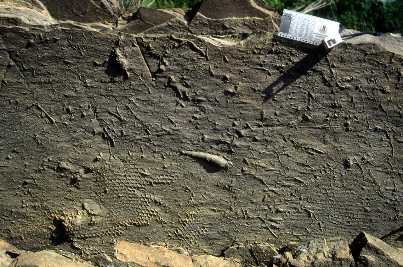
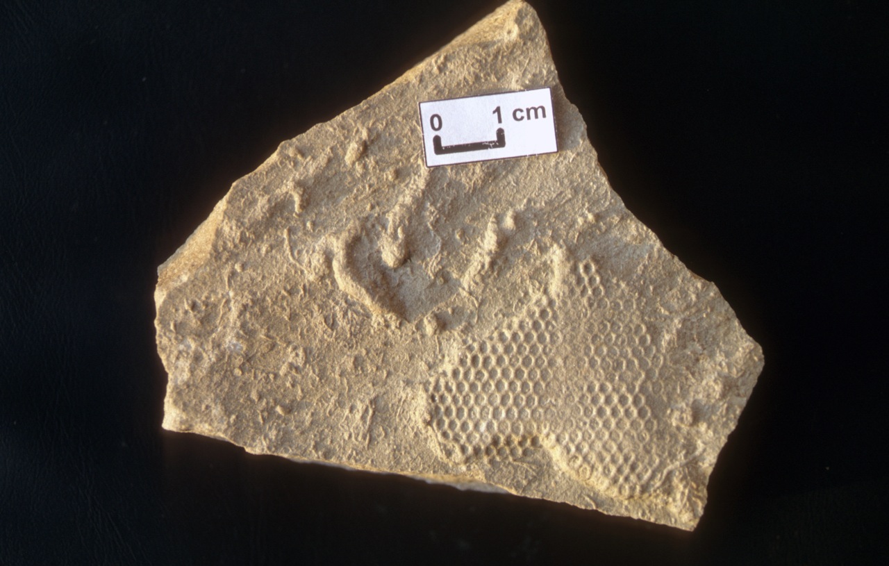
Pinter and Ishman also claim that chevron dunes in Madagascar and on Long Island are aeolian in origin. We visited both locations and found many features that seem incompatible with an aeolian origin. First, parts of the chevrons in both locations contain fist-sized rocks. These rocks are too large to be transported by the wind. Second, the orientations of the chevrons do not match the current prevailing wind direction. In both areas, some of the thicker sand deposits are being reworked into classic windblown dunes. The direction of movement of these dunes differs 8° to 22° from the long-axis of the chevrons. Third, the degree of roundness of the grains in the chevrons is not characteristic of wind transport over long distances. In both locations, sand grains on the distal ends of the chevrons are not well sorted or well rounded. Sand moved by the wind obtains an aeolian size and sorting distribution after only 10–12 km of saltation transport (Sharp, 1966); however, at Ampalaza in Madagascar, the chevron is >40 km long and rises to 63 m above sea level. At its distal end, the chevron is 7.2 km in a direct line from the coast and contains unbroken, unabraded marine microfossils and conchoidally fractured sand grains. It is impossible to transport unabraded marine microfossils to this location via wind-generated saltation. The site is too far above sea level for storm waves, and there is no local agricultural activity. The chevron was deposited by a tsunami.

Well, these seem valid counterarguments at first sight — but it would be nice and it would be time to see actual data: images, measurements, grain size distributions. Which parts of the chevrons are reworked into eolian dunes? What is the difference in the morphology of tsunami dunes and eolian dunes? How does this relate to flow dynamics? What are those “rocks” that occur within the dunes? Where do they occur exactly? And so on. The fact that the authors end their reply with an unqualified strong statement like “The chevron was deposited by a tsunami” suggests that they are unwilling to admit that not every piece of evidence favors their interpretation and that some legitimate questions can be raised. They do this after first admitting that parts of the dunes were indeed reworked into classic wind-blown dunes.

So, at least as far as the ‘chevron dunes’ are concerned, I have to concur with Pinter and Ishman’s harsh conclusion:

Both the 12.9-ka impact and the Holocene mega-tsunami appear to be spectacular explanations on long fishing expeditions for shreds of support. Both stories have played out primarily in the popular press, highlighting how successful impact events can be in attracting attention. The desire for such attention is understandable in an environment where science and scientific funding are increasingly competitive. The National Science Foundation now emphasizes “transformative” research, and few events are as transformative as an impact. In an era when evolution, geologic deep time, and global warming are under assault, this type of “science by press release” and spectacular stories to explain unspectacular evidence consume the finite commodity of scientific credibility.

References

Pinter, N., Ishman, S.E. (2008). Impacts, mega-tsunami, and other extraordinary claims. GSA Today, 18(1), 37. DOI: 10.1130/GSAT01801GW.1

Abbott, D.H., Bryant, E.F., Gusiakov, V., Masse, W., Breger, D. (2008). Impacts, mega-tsunami, and other extraordinary claims: COMMENT. GSA Today, 18(6), e12.

Firestone, R.B., West, A., Kennett, J.P., Becker, L., Bunch, T.E., Revay, Z.S., Schultz, P.H., Belgya, T., Kennett, D.J., Erlandson, J.M., Dickenson, O.J., Goodyear, A.C., Harris, R.S., Howard, G.A., Kloosterman, J.B., Lechler, P., Mayewski, P.A., Montgomery, J., Poreda, R., Darrah, T., Hee, S.S., Smith, A.R., Stich, A., Topping, W., Wittke, J.H., Wolbach, W.S. (2007). Evidence for an extraterrestrial impact 12,900 years ago that contributed to the megafaunal extinctions and the Younger Dryas cooling. Proceedings of the National Academy of Sciences, 104(41), 16016-16021. DOI: 10.1073/pnas.0706977104